


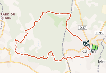
caillan
© OpenStreetMap contributors


5h09
Difficulty : Medium


Length
12.4 km
Max alt
416 m
Uphill gradient
372 m
Km-Effort
17.3 km
Min alt
221 m
Downhill gradient
340 m
Boucle
Yes
Creation date :
2025-01-05 08:28:31.276
Updated on :
2025-01-06 16:14:35.322
5h09
Difficulty : Medium
FREE GPS app for hiking
 SityTrail
IGN / Geographical institutes
SityTrail Plus
The world is yours!
About
Trail Walking of 12.4 km to be discovered at Provence-Alpes-Côte d'Azur, Var, Callian. This trail is proposed by Denis Danielle Berthier.
Description
rando mouans sartoux
Positioning
Country:
France
Region :
Provence-Alpes-Côte d'Azur
Department/Province :
Var
Municipality :
Callian
Location:
Unknown
Start:(Dec)
Start:(UTM)
318768 ; 4832242 (32T) N.
Comments