


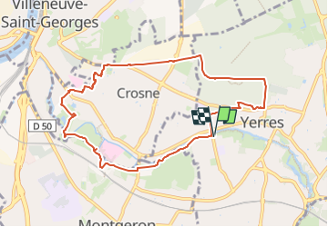
Bord Yerres - Hospital - Mont Griffon 9km

jeanmarcMasson
User GUIDE

Length
9.1 km

Max alt
121 m

Uphill gradient
124 m
Km-Effort
10.8 km

Min alt
31 m

Downhill gradient
124 m
Boucle
Yes
Creation date :
2025-01-07 09:17:28.594
Updated on :
2025-01-07 09:18:56.346
2h27
Difficulty : Medium

FREE GPS app for hiking
 SityTrail
IGN / Geographical institutes
SityTrail Plus
The world is yours!
About
Trail Walking of 9.1 km to be discovered at Ile-de-France, Essonne, Yerres. This trail is proposed by jeanmarcMasson.
Positioning
Country:
France
Region :
Ile-de-France
Department/Province :
Essonne
Municipality :
Yerres
Location:
Unknown
Start:(Dec)
Start:(UTM)
461670 ; 5395911 (31U) N.
Comments