2015-06-08 Rando Chateau de Valnay Matin

jchezlemas
User
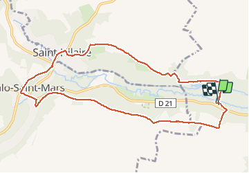

Length
10.1 km

Max alt
144 m

Uphill gradient
197 m
Km-Effort
12.8 km

Min alt
78 m

Downhill gradient
204 m
Boucle
Yes
Creation date :
2015-06-08 00:00:00.0
Updated on :
2015-06-08 00:00:00.0
2h44
Difficulty : Easy

FREE GPS app for hiking
 SityTrail
IGN / Geographical institutes
SityTrail Plus
The world is yours!
About
Trail Walking of 10.1 km to be discovered at Ile-de-France, Essonne, Étampes. This trail is proposed by jchezlemas.
Positioning
Country:
France
Region :
Ile-de-France
Department/Province :
Essonne
Municipality :
Étampes
Location:
Unknown
Start:(Dec)
Start:(UTM)
434495 ; 5363971 (31U) N.
Comments