


M2PMF

fb30
User
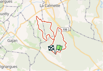

Length
15.9 km

Max alt
179 m

Uphill gradient
248 m
Km-Effort
19.2 km

Min alt
75 m

Downhill gradient
250 m
Boucle
Yes
Creation date :
2025-01-09 13:08:46.0
Updated on :
2025-01-09 14:39:14.414

FREE GPS app for hiking
 SityTrail
IGN / Geographical institutes
SityTrail Plus
The world is yours!
About
Trail of 15.9 km to be discovered at Occitania, Gard, Nimes. This trail is proposed by fb30.

Positioning
Country:
France
Region :
Occitania
Department/Province :
Gard
Municipality :
Nimes
Location:
Unknown
Start:(Dec)
Start:(UTM)
601776 ; 4859818 (31T) N.
Comments