


Limonest - Mont Verdun

Jean-Marc C
User
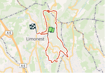

Length
9.1 km

Max alt
592 m

Uphill gradient
292 m
Km-Effort
13.1 km

Min alt
352 m

Downhill gradient
324 m
Boucle
No
Creation date :
2025-01-09 08:21:12.375
Updated on :
2025-01-12 20:20:05.644
2h58
Difficulty : Medium

FREE GPS app for hiking
 SityTrail
IGN / Geographical institutes
SityTrail Plus
The world is yours!
About
Trail Walking of 9.1 km to be discovered at Auvergne-Rhône-Alpes, Métropole de Lyon, Limonest. This trail is proposed by Jean-Marc C.
Photos


Positioning
Country:
France
Region :
Auvergne-Rhône-Alpes
Department/Province :
Métropole de Lyon
Municipality :
Limonest
Location:
Unknown
Start:(Dec)
Start:(UTM)
638089 ; 5077438 (31T) N.
Comments