


clinique duparc

labarone
User
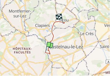

Length
5.2 km

Max alt
75 m

Uphill gradient
81 m
Km-Effort
6.2 km

Min alt
28 m

Downhill gradient
37 m
Boucle
No
Creation date :
2025-01-12 15:26:34.728
Updated on :
2025-01-12 15:44:58.685
18m
Difficulty : Very easy

FREE GPS app for hiking
 SityTrail
IGN / Geographical institutes
SityTrail Plus
The world is yours!
About
Trail Walking of 5.2 km to be discovered at Occitania, Hérault, Castelnau-le-Lez. This trail is proposed by labarone.
Positioning
Country:
France
Region :
Occitania
Department/Province :
Hérault
Municipality :
Castelnau-le-Lez
Location:
Unknown
Start:(Dec)
Start:(UTM)
571833 ; 4831728 (31T) N.
Comments