


Forêt M

Laurent53
User
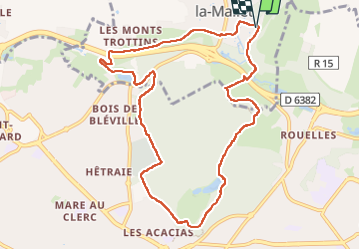

Length
9.9 km

Max alt
93 m

Uphill gradient
161 m
Km-Effort
12 km

Min alt
23 m

Downhill gradient
158 m
Boucle
Yes
Creation date :
2025-01-14 12:25:31.101
Updated on :
2025-01-14 15:34:40.89
3h08
Difficulty : Difficult

FREE GPS app for hiking
 SityTrail
IGN / Geographical institutes
SityTrail Plus
The world is yours!
About
Trail Walking of 9.9 km to be discovered at Normandy, Seine-Maritime, Fontaine-la-Mallet. This trail is proposed by Laurent53.
Positioning
Country:
France
Region :
Normandy
Department/Province :
Seine-Maritime
Municipality :
Fontaine-la-Mallet
Location:
Unknown
Start:(Dec)
Start:(UTM)
293906 ; 5490670 (31U) N.
Comments