


2025-01-14_16h38m27_Lussas - Oppidum de Jastres-Nord

Linerou
User
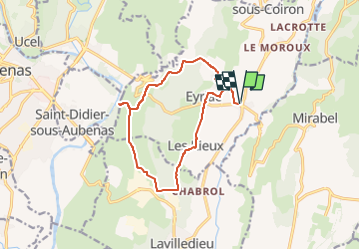

Length
13.5 km

Max alt
344 m

Uphill gradient
180 m
Km-Effort
15.9 km

Min alt
261 m

Downhill gradient
180 m
Boucle
Yes
Creation date :
2025-01-14 15:38:27.038
Updated on :
2025-02-17 18:24:21.656
3h36
Difficulty : Medium

FREE GPS app for hiking
 SityTrail
IGN / Geographical institutes
SityTrail Plus
The world is yours!
About
Trail Walking of 13.5 km to be discovered at Auvergne-Rhône-Alpes, Ardèche, Lussas. This trail is proposed by Linerou.
Positioning
Country:
France
Region :
Auvergne-Rhône-Alpes
Department/Province :
Ardèche
Municipality :
Lussas
Location:
Unknown
Start:(Dec)
Start:(UTM)
616823 ; 4940919 (31T) N.
Comments