


Les Echelles Rochehaut

ramagufa
User
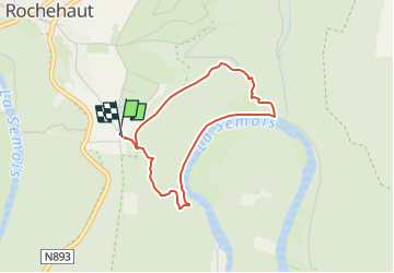

Length
3.2 km

Max alt
376 m

Uphill gradient
168 m
Km-Effort
5.4 km

Min alt
207 m

Downhill gradient
168 m
Boucle
Yes
Creation date :
2025-01-14 17:50:00.58
Updated on :
2025-03-08 13:58:51.524
1h13
Difficulty : Easy

FREE GPS app for hiking
 SityTrail
IGN / Geographical institutes
SityTrail Plus
The world is yours!
About
Trail Walking of 3.2 km to be discovered at Wallonia, Luxembourg, Bouillon. This trail is proposed by ramagufa.
Description
courte mais accidentée
on peut partir de l'eglise qui allonge la rando de /- 2 km
Positioning
Country:
Belgium
Region :
Wallonia
Department/Province :
Luxembourg
Municipality :
Bouillon
Location:
Unknown
Start:(Dec)
Start:(UTM)
644723 ; 5522131 (31U) N.
Comments