


Rando 8/10 Martine
© OpenStreetMap contributors


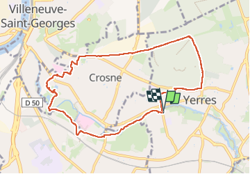
Length
9.5 km
Max alt
99 m
Uphill gradient
101 m
Km-Effort
10.8 km
Min alt
31 m
Downhill gradient
101 m
Boucle
Yes
Creation date :
2025-01-15 12:30:46.0
Updated on :
2025-01-15 15:08:25.539
FREE GPS app for hiking
 SityTrail
IGN / Geographical institutes
SityTrail Plus
The world is yours!
About
Trail of 9.5 km to be discovered at Ile-de-France, Essonne, Yerres. This trail is proposed by 001185.1a411e07e05844e0b21535b8a6fe40df.0829.
Description
Marche de 9kms
Positioning
Country:
France
Region :
Ile-de-France
Department/Province :
Essonne
Municipality :
Yerres
Location:
Unknown
Start:(Dec)
Start:(UTM)
461683 ; 5395868 (31U) N.
Comments