


004rd. faisanderie

tine60
User
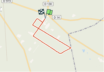

Length
5.7 km

Max alt
67 m

Uphill gradient
65 m
Km-Effort
6.6 km

Min alt
49 m

Downhill gradient
66 m
Boucle
Yes
Creation date :
2025-01-16 13:29:16.101
Updated on :
2025-01-16 14:51:43.352
1h16
Difficulty : Medium

FREE GPS app for hiking
 SityTrail
IGN / Geographical institutes
SityTrail Plus
The world is yours!
About
Trail Walking of 5.7 km to be discovered at Hauts-de-France, Oise, Compiègne. This trail is proposed by tine60.
Positioning
Country:
France
Region :
Hauts-de-France
Department/Province :
Oise
Municipality :
Compiègne
Location:
Unknown
Start:(Dec)
Start:(UTM)
490676 ; 5471520 (31U) N.
Comments