


Voguë

Alaint07
User

Length
8.4 km

Max alt
323 m

Uphill gradient
226 m
Km-Effort
11.4 km

Min alt
158 m

Downhill gradient
220 m
Boucle
Yes
Creation date :
2025-01-16 13:16:05.736
Updated on :
2025-01-17 17:24:55.139
2h35
Difficulty : Medium

FREE GPS app for hiking
 SityTrail
IGN / Geographical institutes
SityTrail Plus
The world is yours!
About
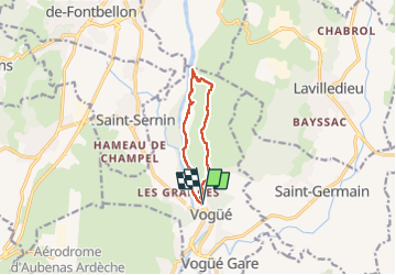
Trail Walking of 8.4 km to be discovered at Auvergne-Rhône-Alpes, Ardèche, Vogüé. This trail is proposed by Alaint07.
Description
Le long de l'Ardèche puis sur les gras avec vues.
Difficile entre 1 et 2 , pas de chemin et dénivelé.
Photos


Positioning
Country:
France
Region :
Auvergne-Rhône-Alpes
Department/Province :
Ardèche
Municipality :
Vogüé
Location:
Unknown
Start:(Dec)
Start:(UTM)
612241 ; 4934153 (31T) N.
Comments