


Galliciian

Dupuybadonniere
User
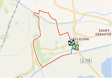

Length
8.1 km

Max alt
40 m

Uphill gradient
52 m
Km-Effort
8.8 km

Min alt
-2 m

Downhill gradient
52 m
Boucle
No
Creation date :
2025-01-17 13:00:53.319
Updated on :
2025-01-17 15:08:44.45
1h56
Difficulty : Medium

FREE GPS app for hiking
 SityTrail
IGN / Geographical institutes
SityTrail Plus
The world is yours!
About
Trail Walking of 8.1 km to be discovered at Occitania, Gard, Vauvert. This trail is proposed by Dupuybadonniere.
Positioning
Country:
France
Region :
Occitania
Department/Province :
Gard
Municipality :
Vauvert
Location:
Unknown
Start:(Dec)
Start:(UTM)
604382 ; 4832413 (31T) N.
Comments