


Petite balade des Eyssaras au lac de MISON

babouille
User
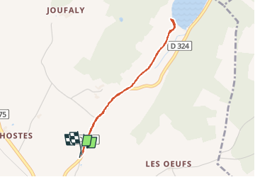

Length
3.4 km

Max alt
636 m

Uphill gradient
34 m
Km-Effort
3.8 km

Min alt
614 m

Downhill gradient
33 m
Boucle
Yes
Creation date :
2025-01-18 09:17:33.0
Updated on :
2025-01-18 10:07:02.889

FREE GPS app for hiking
 SityTrail
IGN / Geographical institutes
SityTrail Plus
The world is yours!
About
Trail of 3.4 km to be discovered at Provence-Alpes-Côte d'Azur, Alpes-de-Haute-Provence, Mison. This trail is proposed by babouille.
Description
Sans difficulté
Positioning
Country:
France
Region :
Provence-Alpes-Côte d'Azur
Department/Province :
Alpes-de-Haute-Provence
Municipality :
Mison
Location:
Unknown
Start:(Dec)
Start:(UTM)
728048 ; 4906733 (31T) N.
Comments