


vaunaveyts

raygautier
User

Length
18.4 km

Max alt
619 m

Uphill gradient
855 m
Km-Effort
30 km

Min alt
264 m

Downhill gradient
858 m
Boucle
Yes
Creation date :
2025-01-19 08:52:13.094
Updated on :
2025-01-19 19:18:57.09
6h28
Difficulty : Very difficult

FREE GPS app for hiking
 SityTrail
IGN / Geographical institutes
SityTrail Plus
The world is yours!
About
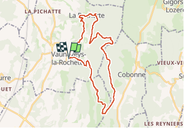
Trail Walking of 18.4 km to be discovered at Auvergne-Rhône-Alpes, Drôme, Vaunaveys-la-Rochette. This trail is proposed by raygautier.
Positioning
Country:
France
Region :
Auvergne-Rhône-Alpes
Department/Province :
Drôme
Municipality :
Vaunaveys-la-Rochette
Location:
Unknown
Start:(Dec)
Start:(UTM)
660960 ; 4959172 (31T) N.
Comments