


R1T-A517-Château de la Reine blanche

Jack-94
User
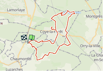

Length
21 km

Max alt
134 m

Uphill gradient
324 m
Km-Effort
25 km

Min alt
35 m

Downhill gradient
324 m
Boucle
Yes
Creation date :
2025-01-19 08:38:54.95
Updated on :
2025-01-19 20:19:31.28
6h55
Difficulty : Very difficult

FREE GPS app for hiking
 SityTrail
IGN / Geographical institutes
SityTrail Plus
The world is yours!
About
Trail Walking of 21 km to be discovered at Ile-de-France, Val-d'Oise, Chaumontel. This trail is proposed by Jack-94.
Positioning
Country:
France
Region :
Ile-de-France
Department/Province :
Val-d'Oise
Municipality :
Chaumontel
Location:
Unknown
Start:(Dec)
Start:(UTM)
459084 ; 5442364 (31U) N.
Comments