


Bagnols en Forêt les meules

alinetpierre
User
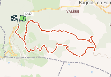

Length
14.3 km

Max alt
419 m

Uphill gradient
461 m
Km-Effort
20 km

Min alt
202 m

Downhill gradient
459 m
Boucle
Yes
Creation date :
2025-01-19 08:43:29.0
Updated on :
2025-01-20 09:45:55.213

FREE GPS app for hiking
 SityTrail
IGN / Geographical institutes
SityTrail Plus
The world is yours!
About
Trail of 14.3 km to be discovered at Provence-Alpes-Côte d'Azur, Var, Bagnols-en-Forêt. This trail is proposed by alinetpierre.
Description
Très bon balisage randonnée facile sentiers variés, très beau point de vue , attention pour la forteresse c’est un aller retour
Photos


Positioning
Country:
France
Region :
Provence-Alpes-Côte d'Azur
Department/Province :
Var
Municipality :
Bagnols-en-Forêt
Location:
Unknown
Start:(Dec)
Start:(UTM)
310491 ; 4822155 (32T) N.
Comments