


Chemin de la Charmotte

kikkko
User
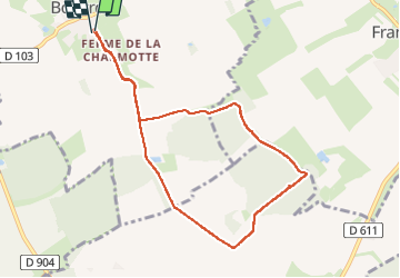

Length
8.1 km

Max alt
231 m

Uphill gradient
68 m
Km-Effort
9 km

Min alt
209 m

Downhill gradient
68 m
Boucle
Yes
Creation date :
2025-01-20 13:01:42.549
Updated on :
2025-01-20 15:22:34.49
1h56
Difficulty : Medium

FREE GPS app for hiking
 SityTrail
IGN / Geographical institutes
SityTrail Plus
The world is yours!
About
Trail Walking of 8.1 km to be discovered at Grand Est, Meurthe-et-Moselle, Bouvron. This trail is proposed by kikkko.
Description
balisé rond bleu par les baliseurs de la Linotte
merci à eux
Positioning
Country:
France
Region :
Grand Est
Department/Province :
Meurthe-et-Moselle
Municipality :
Bouvron
Location:
Unknown
Start:(Dec)
Start:(UTM)
711949 ; 5402550 (31U) N.
Comments