


Vaunaveys-la Rochette

raygautier
User
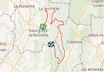

Length
15.1 km

Max alt
619 m

Uphill gradient
806 m
Km-Effort
25 km

Min alt
262 m

Downhill gradient
662 m
Boucle
No
Creation date :
2025-01-19 08:56:03.0
Updated on :
2025-01-20 16:28:05.506
4h55
Difficulty : Very difficult

FREE GPS app for hiking
 SityTrail
IGN / Geographical institutes
SityTrail Plus
The world is yours!
About
Trail Walking of 15.1 km to be discovered at Auvergne-Rhône-Alpes, Drôme, Vaunaveys-la-Rochette. This trail is proposed by raygautier.
Positioning
Country:
France
Region :
Auvergne-Rhône-Alpes
Department/Province :
Drôme
Municipality :
Vaunaveys-la-Rochette
Location:
Unknown
Start:(Dec)
Start:(UTM)
660986 ; 4959165 (31T) N.
Comments