


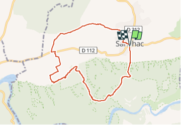
Autour de Sanilhac P2

GOIOLIRIBES
User

Length
8.8 km

Max alt
179 m

Uphill gradient
133 m
Km-Effort
10.6 km

Min alt
61 m

Downhill gradient
133 m
Boucle
Yes
Creation date :
2025-01-21 09:49:14.425
Updated on :
2025-01-21 17:17:05.264
2h23
Difficulty : Medium

FREE GPS app for hiking
 SityTrail
IGN / Geographical institutes
SityTrail Plus
The world is yours!
About
Trail Walking of 8.8 km to be discovered at Occitania, Gard, Sanilhac-Sagriès. This trail is proposed by GOIOLIRIBES.
Description
Petite marche de mise en appétit. Depart place de la mairie de Sanilhac.
Positioning
Country:
France
Region :
Occitania
Department/Province :
Gard
Municipality :
Sanilhac-Sagriès
Location:
Unknown
Start:(Dec)
Start:(UTM)
614366 ; 4867691 (31T) N.
Comments