


st blaise

losjo
User
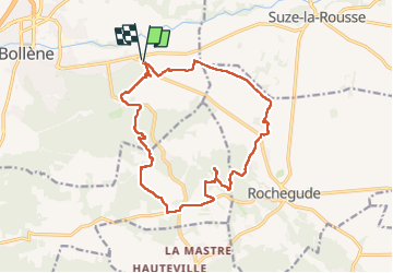

Length
16.8 km

Max alt
186 m

Uphill gradient
257 m
Km-Effort
20 km

Min alt
70 m

Downhill gradient
259 m
Boucle
Yes
Creation date :
2025-01-21 07:34:36.968
Updated on :
2025-01-21 13:52:25.286
6h16
Difficulty : Very easy

FREE GPS app for hiking
 SityTrail
IGN / Geographical institutes
SityTrail Plus
The world is yours!
About
Trail Walking of 16.8 km to be discovered at Provence-Alpes-Côte d'Azur, Vaucluse, Bollène. This trail is proposed by losjo.
Positioning
Country:
France
Region :
Provence-Alpes-Côte d'Azur
Department/Province :
Vaucluse
Municipality :
Bollène
Location:
Unknown
Start:(Dec)
Start:(UTM)
642477 ; 4904367 (31T) N.
Comments