


A la découverte de Tielt 🥾

Ko-Rando
User

Length
6.7 km

Max alt
84 m

Uphill gradient
66 m
Km-Effort
7.6 km

Min alt
29 m

Downhill gradient
66 m
Boucle
Yes
Creation date :
2025-01-21 15:02:29.825
Updated on :
2025-01-21 16:55:17.663
1h35
Difficulty : Very easy

FREE GPS app for hiking
 SityTrail
IGN / Geographical institutes
SityTrail Plus
The world is yours!
About
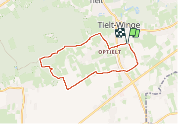
Trail Walking of 6.7 km to be discovered at Flanders, Flemish Brabant, Tielt-Winge. This trail is proposed by Ko-Rando.
Photos


Positioning
Country:
Belgium
Region :
Flanders
Department/Province :
Flemish Brabant
Municipality :
Tielt-Winge
Location:
Tielt
Start:(Dec)
Start:(UTM)
634432 ; 5643895 (31U) N.
Comments