


Belesta les crêtes

robertperello
User
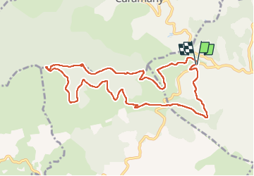

Length
11.2 km

Max alt
655 m

Uphill gradient
351 m
Km-Effort
15.9 km

Min alt
324 m

Downhill gradient
347 m
Boucle
Yes
Creation date :
2025-01-22 08:41:25.0
Updated on :
2025-01-22 12:44:37.091
2h59
Difficulty : Easy

FREE GPS app for hiking
 SityTrail
IGN / Geographical institutes
SityTrail Plus
The world is yours!
About
Trail Walking of 11.2 km to be discovered at Occitania, Pyrénées-Orientales, Bélesta. This trail is proposed by robertperello.
Description
Pking et départ citerne 191 sur la route Belesta Montalba
Positioning
Country:
France
Region :
Occitania
Department/Province :
Pyrénées-Orientales
Municipality :
Bélesta
Location:
Unknown
Start:(Dec)
Start:(UTM)
466077 ; 4730129 (31T) N.
Comments