


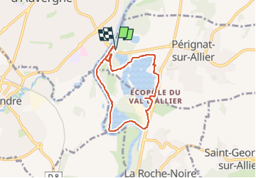
ecopole de cournon 6,5 km

jeanic63
User

Length
6.5 km

Max alt
333 m

Uphill gradient
45 m
Km-Effort
7.1 km

Min alt
319 m

Downhill gradient
44 m
Boucle
Yes
Creation date :
2025-01-23 12:13:12.239
Updated on :
2025-01-26 17:23:01.295
1h36
Difficulty : Medium

FREE GPS app for hiking
 SityTrail
IGN / Geographical institutes
SityTrail Plus
The world is yours!
About
Trail Walking of 6.5 km to be discovered at Auvergne-Rhône-Alpes, Puy-de-Dôme, Pérignat-sur-Allier. This trail is proposed by jeanic63.
Description
départ vers lepont de cournon
Positioning
Country:
France
Region :
Auvergne-Rhône-Alpes
Department/Province :
Puy-de-Dôme
Municipality :
Pérignat-sur-Allier
Location:
Unknown
Start:(Dec)
Start:(UTM)
516681 ; 5063978 (31T) N.
Comments