


ludres par roches

ISAGIL
User
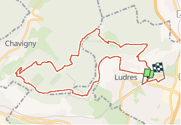

Length
12.7 km

Max alt
418 m

Uphill gradient
270 m
Km-Effort
16.3 km

Min alt
263 m

Downhill gradient
277 m
Boucle
No
Creation date :
2025-01-23 12:23:09.142
Updated on :
2025-01-23 16:03:06.9
3h38
Difficulty : Difficult

FREE GPS app for hiking
 SityTrail
IGN / Geographical institutes
SityTrail Plus
The world is yours!
About
Trail Walking of 12.7 km to be discovered at Grand Est, Meurthe-et-Moselle, Ludres. This trail is proposed by ISAGIL.
Description
ludres
Positioning
Country:
France
Region :
Grand Est
Department/Province :
Meurthe-et-Moselle
Municipality :
Ludres
Location:
Unknown
Start:(Dec)
Start:(UTM)
291184 ; 5389077 (32U) N.
Comments