


Crest

raygautier
User
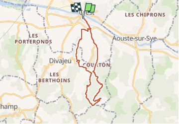

Length
13.8 km

Max alt
430 m

Uphill gradient
360 m
Km-Effort
18.6 km

Min alt
187 m

Downhill gradient
360 m
Boucle
Yes
Creation date :
2025-01-23 11:54:00.0
Updated on :
2025-01-23 16:05:42.519
4h10
Difficulty : Difficult

FREE GPS app for hiking
 SityTrail
IGN / Geographical institutes
SityTrail Plus
The world is yours!
About
Trail Walking of 13.8 km to be discovered at Auvergne-Rhône-Alpes, Drôme, Crest. This trail is proposed by raygautier.
Positioning
Country:
France
Region :
Auvergne-Rhône-Alpes
Department/Province :
Drôme
Municipality :
Crest
Location:
Unknown
Start:(Dec)
Start:(UTM)
660066 ; 4954418 (31T) N.
Comments