


SityTrail - 4329925 - fra-25-01

geranimo
User
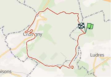

Length
10.2 km

Max alt
422 m

Uphill gradient
222 m
Km-Effort
13.1 km

Min alt
280 m

Downhill gradient
222 m
Boucle
Yes
Creation date :
2025-01-25 19:03:23.0
Updated on :
2025-02-03 23:41:05.633
2h58
Difficulty : Difficult

FREE GPS app for hiking
 SityTrail
IGN / Geographical institutes
SityTrail Plus
The world is yours!
About
Trail Walking of 10.2 km to be discovered at Grand Est, Meurthe-et-Moselle, Ludres. This trail is proposed by geranimo.
Positioning
Country:
France
Region :
Grand Est
Department/Province :
Meurthe-et-Moselle
Municipality :
Ludres
Location:
Unknown
Start:(Dec)
Start:(UTM)
290349 ; 5390205 (32U) N.
Comments