


Ça marche et ça roule

PhilippeC54
User
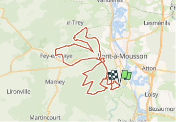

Length
39 km

Max alt
378 m

Uphill gradient
826 m
Km-Effort
50 km

Min alt
178 m

Downhill gradient
826 m
Boucle
Yes
Creation date :
2025-01-26 07:26:26.32
Updated on :
2025-01-26 10:20:09.875
2h53
Difficulty : Difficult

FREE GPS app for hiking
 SityTrail
IGN / Geographical institutes
SityTrail Plus
The world is yours!
About
Trail Mountain bike of 39 km to be discovered at Grand Est, Meurthe-et-Moselle, Jezainville. This trail is proposed by PhilippeC54.
Positioning
Country:
France
Region :
Grand Est
Department/Province :
Meurthe-et-Moselle
Municipality :
Jezainville
Location:
Unknown
Start:(Dec)
Start:(UTM)
283779 ; 5417687 (32U) N.
Comments