


240127 Gembloux-Sauvenière

guy284
User
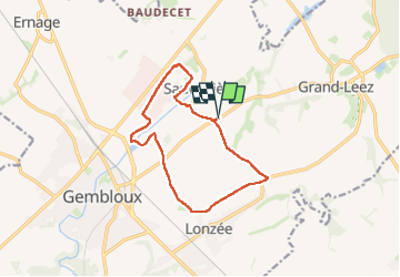

Length
11.1 km

Max alt
172 m

Uphill gradient
91 m
Km-Effort
12.3 km

Min alt
140 m

Downhill gradient
90 m
Boucle
Yes
Creation date :
2025-01-27 13:02:40.853
Updated on :
2025-01-27 15:14:56.562
2h08
Difficulty : Medium

FREE GPS app for hiking
 SityTrail
IGN / Geographical institutes
SityTrail Plus
The world is yours!
About
Trail Walking of 11.1 km to be discovered at Wallonia, Namur, Gembloux. This trail is proposed by guy284.
Positioning
Country:
Belgium
Region :
Wallonia
Department/Province :
Namur
Municipality :
Gembloux
Location:
Unknown
Start:(Dec)
Start:(UTM)
622529 ; 5604017 (31U) N.
Comments