


Gare Tremblay, Antrain 12km A+R. pascal

COGLAIS3
User
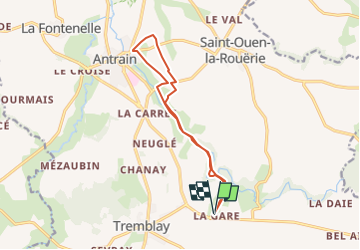

Length
12 km

Max alt
65 m

Uphill gradient
156 m
Km-Effort
14 km

Min alt
14 m

Downhill gradient
154 m
Boucle
Yes
Creation date :
2025-01-28 17:57:20.883
Updated on :
2025-02-01 17:15:56.846
0m
Difficulty : Very easy

FREE GPS app for hiking
 SityTrail
IGN / Geographical institutes
SityTrail Plus
The world is yours!
About
Trail Nordic walking of 12 km to be discovered at Brittany, Ille-et-Vilaine, Val-Couesnon. This trail is proposed by COGLAIS3.
Positioning
Country:
France
Region :
Brittany
Department/Province :
Ille-et-Vilaine
Municipality :
Val-Couesnon
Location:
Tremblay
Start:(Dec)
Start:(UTM)
614620 ; 5364740 (30U) N.
Comments