


villers stanislas

ISAGIL
User

Length
7.1 km

Max alt
365 m

Uphill gradient
174 m
Km-Effort
9.5 km

Min alt
258 m

Downhill gradient
174 m
Boucle
Yes
Creation date :
2025-01-31 07:59:49.103
Updated on :
2025-01-31 10:12:31.618
2h11
Difficulty : Medium

FREE GPS app for hiking
 SityTrail
IGN / Geographical institutes
SityTrail Plus
The world is yours!
About
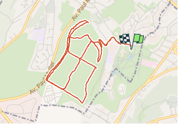
Trail Walking of 7.1 km to be discovered at Grand Est, Meurthe-et-Moselle, Villers-lès-Nancy. This trail is proposed by ISAGIL.
Description
stanislas
Positioning
Country:
France
Region :
Grand Est
Department/Province :
Meurthe-et-Moselle
Municipality :
Villers-lès-Nancy
Location:
Unknown
Start:(Dec)
Start:(UTM)
290552 ; 5393870 (32U) N.
Comments