


Bolus Head loop

FabienneD
User
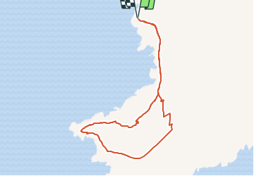

Length
7.8 km

Max alt
278 m

Uphill gradient
326 m
Km-Effort
12.2 km

Min alt
44 m

Downhill gradient
326 m
Boucle
Yes
Creation date :
2015-06-14 00:00:00.0
Updated on :
2015-06-14 00:00:00.0
2h31
Difficulty : Medium

FREE GPS app for hiking
 SityTrail
IGN / Geographical institutes
SityTrail Plus
The world is yours!
About
Trail Walking of 7.8 km to be discovered at Unknown, County Kerry, Kenmare Municipal District. This trail is proposed by FabienneD.
Description
Magnifiques vues sur la cote, les îles Skelling, les champs de moutons, etc.
Positioning
Country:
Ireland
Region :
Unknown
Department/Province :
County Kerry
Municipality :
Kenmare Municipal District
Location:
Ballinskelligs
Start:(Dec)
Start:(UTM)
407818 ; 5741208 (29U) N.
Comments