


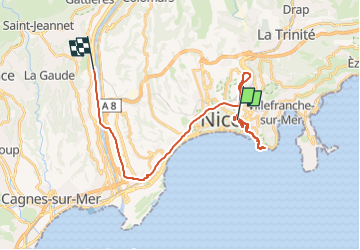
Vers le port de Nice - 02 fév 2025

morganee
User

Length
27 km

Max alt
75 m

Uphill gradient
359 m
Km-Effort
32 km

Min alt
2 m

Downhill gradient
344 m
Boucle
No
Creation date :
2025-02-02 09:32:15.184
Updated on :
2025-02-02 14:26:12.239
3h30
Difficulty : Easy

FREE GPS app for hiking
 SityTrail
IGN / Geographical institutes
SityTrail Plus
The world is yours!
About
Trail Walking of 27 km to be discovered at Provence-Alpes-Côte d'Azur, Maritime Alps, Nice. This trail is proposed by morganee.
Positioning
Country:
France
Region :
Provence-Alpes-Côte d'Azur
Department/Province :
Maritime Alps
Municipality :
Nice
Location:
Unknown
Start:(Dec)
Start:(UTM)
361368 ; 4840088 (32T) N.
Comments