


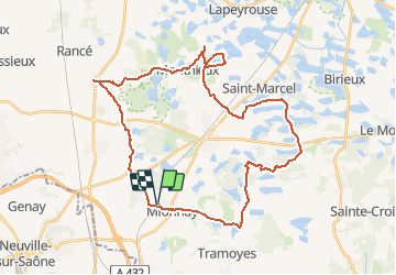
Mionnay-40km-308m

ThierryJ01
User

Length
40 km

Max alt
310 m

Uphill gradient
308 m
Km-Effort
44 km

Min alt
269 m

Downhill gradient
308 m
Boucle
Yes
Creation date :
2015-06-15 00:00:00.0
Updated on :
2020-10-09 20:55:35.145
2h56
Difficulty : Easy

FREE GPS app for hiking
 SityTrail
IGN / Geographical institutes
SityTrail Plus
The world is yours!
About
Trail Mountain bike of 40 km to be discovered at Auvergne-Rhône-Alpes, Ain, Mionnay. This trail is proposed by ThierryJ01.
Positioning
Country:
France
Region :
Auvergne-Rhône-Alpes
Department/Province :
Ain
Municipality :
Mionnay
Location:
Unknown
Start:(Dec)
Start:(UTM)
649150 ; 5084442 (31T) N.
Comments