


Rando chemin du petit bonheur 22km

jeanmarcMasson
User GUIDE
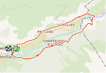

Length
12 km

Max alt
1796 m

Uphill gradient
462 m
Km-Effort
18.1 km

Min alt
1470 m

Downhill gradient
467 m
Boucle
Yes
Creation date :
2025-02-02 08:04:48.185
Updated on :
2025-02-02 16:01:50.431
4h23
Difficulty : Medium

FREE GPS app for hiking
 SityTrail
IGN / Geographical institutes
SityTrail Plus
The world is yours!
About
Trail Snowshoes of 12 km to be discovered at Auvergne-Rhône-Alpes, Savoy, Val-Cenis. This trail is proposed by jeanmarcMasson.
Positioning
Country:
France
Region :
Auvergne-Rhône-Alpes
Department/Province :
Savoy
Municipality :
Val-Cenis
Location:
Lanslevillard
Start:(Dec)
Start:(UTM)
336688 ; 5017245 (32T) N.
Comments