


St Etienne la Mûre 3/02/25

Linerou
User
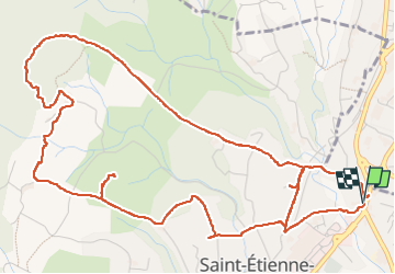

Length
8 km

Max alt
332 m

Uphill gradient
181 m
Km-Effort
10.4 km

Min alt
200 m

Downhill gradient
181 m
Boucle
Yes
Creation date :
2025-02-03 08:06:43.138
Updated on :
2025-02-03 10:29:59.399
2h17
Difficulty : Easy

FREE GPS app for hiking
 SityTrail
IGN / Geographical institutes
SityTrail Plus
The world is yours!
About
Trail Walking of 8 km to be discovered at Auvergne-Rhône-Alpes, Ardèche, Saint-Étienne-de-Fontbellon. This trail is proposed by Linerou.
Positioning
Country:
France
Region :
Auvergne-Rhône-Alpes
Department/Province :
Ardèche
Municipality :
Saint-Étienne-de-Fontbellon
Location:
Unknown
Start:(Dec)
Start:(UTM)
610026 ; 4939577 (31T) N.
Comments