


rando Lac Cenis

jeanmarcMasson
User GUIDE
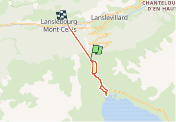

Length
5.5 km

Max alt
2095 m

Uphill gradient
198 m
Km-Effort
8.2 km

Min alt
1971 m

Downhill gradient
197 m
Boucle
Yes
Creation date :
2025-02-04 08:42:45.384
Updated on :
2025-02-05 19:55:38.445
2h28
Difficulty : Very easy

FREE GPS app for hiking
 SityTrail
IGN / Geographical institutes
SityTrail Plus
The world is yours!
About
Trail Snowshoes of 5.5 km to be discovered at Auvergne-Rhône-Alpes, Savoy, Val-Cenis. This trail is proposed by jeanmarcMasson.
Positioning
Country:
France
Region :
Auvergne-Rhône-Alpes
Department/Province :
Savoy
Municipality :
Val-Cenis
Location:
Lanslebourg-Mont-Cenis
Start:(Dec)
Start:(UTM)
335182 ; 5014880 (32T) N.
Comments