


boucle tremblay14km, pascal

COGLAIS3
User
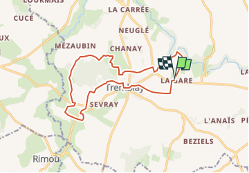

Length
14.5 km

Max alt
107 m

Uphill gradient
223 m
Km-Effort
17.4 km

Min alt
21 m

Downhill gradient
223 m
Boucle
Yes
Creation date :
2025-02-04 18:16:57.168
Updated on :
2025-02-05 08:48:57.296
0m
Difficulty : Very easy

FREE GPS app for hiking
 SityTrail
IGN / Geographical institutes
SityTrail Plus
The world is yours!
About
Trail Nordic walking of 14.5 km to be discovered at Brittany, Ille-et-Vilaine, Val-Couesnon. This trail is proposed by COGLAIS3.
Positioning
Country:
France
Region :
Brittany
Department/Province :
Ille-et-Vilaine
Municipality :
Val-Couesnon
Location:
Tremblay
Start:(Dec)
Start:(UTM)
614609 ; 5364720 (30U) N.
Comments