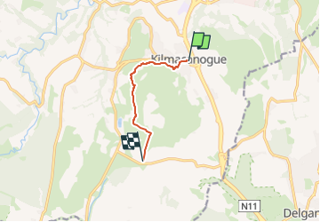
Trail On foot Unknown - The Sugar Loaf Way - Photo

The Sugar Loaf Way

Tous les sentiers balisés d’Europe GUIDE+

© OpenStreetMap contributors
Length
Length
4.5 km
Max alt
Max alt
374 m
Uphill gradient
Uphill gradient
286 m
Km-Effort
Km-Effort  
7.6 km
Min alt
Min alt
89 m
Downhill gradient
Downhill gradient
77 m
Boucle
Boucle
No
Signpost
Signpost
Creation date :
2025-02-06 12:58:23.881
Updated on :
2025-02-06 12:58:23.881

(0 Reviews)

On foot
On foot
1h43
Difficulty : Easy

Scan this QR Code to open this trail in the SityTrail application

FREE GPS app for hiking

Logo SityTrail SityTrail

IGN / Geographical institutes

Download SityTrail from the App Store Download SityTrail from Google Play

Logo SityTrail SityTrail Plus

The world is yours!

Download SityTrail from the App Store Download SityTrail from Google Play Download SityTrail on Huawei AppGallery

About

Trail On foot of 4.5 km to be discovered at Unknown, Unknown, Unknown. This trail is proposed by SityTrail - itinéraires balisés pédestres.

Description

Trail created by Wicklow Uplands Council.

Symbol: Yellow Hiker


Website: http://www.wicklowuplands.ie/the-sugar-loaf-way-3/

Elevation profile

Photos

Positioning

Country:
Ireland
Region :
Unknown
Department/Province :
Unknown
Municipality :
Unknown
Location:
Glencullen ED
Start:(UTM)
691352 ; 5894783 (29U) N.


Close
My subscriptions