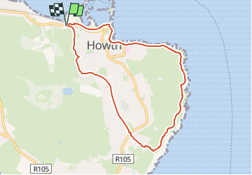
Trail On foot Unknown - Howth Tramline Loop - Photo

Howth Tramline Loop

Tous les sentiers balisés d’Europe GUIDE+

© OpenStreetMap contributors
Length
Length
7 km
Max alt
Max alt
140 m
Uphill gradient
Uphill gradient
159 m
Km-Effort
Km-Effort  
9.1 km
Min alt
Min alt
0 m
Downhill gradient
Downhill gradient
154 m
Boucle
Boucle
Yes
Signpost
Signpost
Creation date :
2025-02-06 13:10:26.057
Updated on :
2025-02-06 13:10:26.057

(0 Reviews)

On foot
On foot
2h04
Difficulty : Easy

Scan this QR Code to open this trail in the SityTrail application

FREE GPS app for hiking

Logo SityTrail SityTrail

IGN / Geographical institutes

Download SityTrail from the App Store Download SityTrail from Google Play

Logo SityTrail SityTrail Plus

The world is yours!

Download SityTrail from the App Store Download SityTrail from Google Play Download SityTrail on Huawei AppGallery

About

Trail On foot of 7 km to be discovered at Unknown, Unknown, Unknown. This trail is proposed by SityTrail - itinéraires balisés pédestres.

Description

Symbol: Blue arrow on white background


Website: https://www.irishtrails.ie/Trail/Howth---Tramline-loop/108/

Elevation profile

Photos

Positioning

Country:
Ireland
Region :
Unknown
Department/Province :
Unknown
Municipality :
Unknown
Location:
Ballymun C ED
Start:(UTM)
694562 ; 5919506 (29U) N.


Close
My subscriptions