


viterne circuits des croix

ISAGIL
User
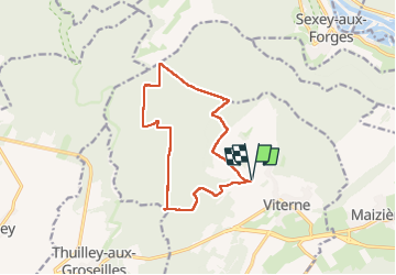

Length
12.3 km

Max alt
367 m

Uphill gradient
152 m
Km-Effort
14.3 km

Min alt
285 m

Downhill gradient
152 m
Boucle
Yes
Creation date :
2025-02-06 12:48:42.6
Updated on :
2025-02-06 16:00:13.453
3h10
Difficulty : Difficult

FREE GPS app for hiking
 SityTrail
IGN / Geographical institutes
SityTrail Plus
The world is yours!
About
Trail Walking of 12.3 km to be discovered at Grand Est, Meurthe-et-Moselle, Viterne. This trail is proposed by ISAGIL.
Description
viterne
Photos


Positioning
Country:
France
Region :
Grand Est
Department/Province :
Meurthe-et-Moselle
Municipality :
Viterne
Location:
Unknown
Start:(Dec)
Start:(UTM)
280403 ; 5386365 (32U) N.
Comments