


Sainte Hélène les deux sources page 37

grasgilbert
User
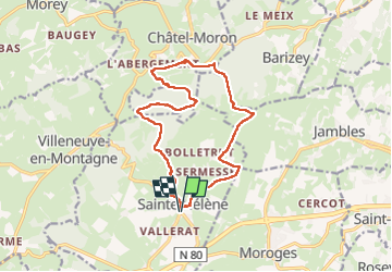

Length
14.4 km

Max alt
501 m

Uphill gradient
340 m
Km-Effort
18.9 km

Min alt
314 m

Downhill gradient
340 m
Boucle
Yes
Creation date :
2025-02-06 12:23:11.558
Updated on :
2025-02-06 17:28:13.995
4h17
Difficulty : Difficult

FREE GPS app for hiking
 SityTrail
IGN / Geographical institutes
SityTrail Plus
The world is yours!
About
Trail Walking of 14.4 km to be discovered at Bourgogne-Franche-Comté, Saône-et-Loire, Sainte-Hélène. This trail is proposed by grasgilbert.
Description
très mouillé en hiver
Positioning
Country:
France
Region :
Bourgogne-Franche-Comté
Department/Province :
Saône-et-Loire
Municipality :
Sainte-Hélène
Location:
Unknown
Start:(Dec)
Start:(UTM)
625524 ; 5179322 (31T) N.
Comments