


Lanslevillard - Chapelle st Genix - Rocher des sarrasins - 6,5 km

jeanmarcMasson
User GUIDE
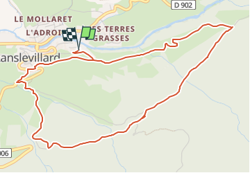

Length
6.5 km

Max alt
1751 m

Uphill gradient
273 m
Km-Effort
10.1 km

Min alt
1487 m

Downhill gradient
270 m
Boucle
Yes
Creation date :
2025-02-06 20:52:44.993
Updated on :
2025-02-06 20:55:51.216
3h00
Difficulty : Very easy

FREE GPS app for hiking
 SityTrail
IGN / Geographical institutes
SityTrail Plus
The world is yours!
About
Trail Snowshoes of 6.5 km to be discovered at Auvergne-Rhône-Alpes, Savoy, Val-Cenis. This trail is proposed by jeanmarcMasson.
Positioning
Country:
France
Region :
Auvergne-Rhône-Alpes
Department/Province :
Savoy
Municipality :
Val-Cenis
Location:
Lanslevillard
Start:(Dec)
Start:(UTM)
336729 ; 5017262 (32T) N.
Comments