


pscolletredon

psester
User
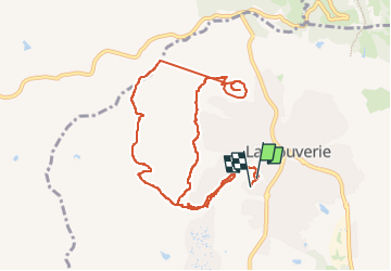

Length
12 km

Max alt
202 m

Uphill gradient
242 m
Km-Effort
15.3 km

Min alt
32 m

Downhill gradient
240 m
Boucle
Yes
Creation date :
2025-01-24 08:05:45.946
Updated on :
2025-02-24 13:53:21.862
3h28
Difficulty : Difficult

FREE GPS app for hiking
 SityTrail
IGN / Geographical institutes
SityTrail Plus
The world is yours!
About
Trail Walking of 12 km to be discovered at Provence-Alpes-Côte d'Azur, Var, Roquebrune-sur-Argens. This trail is proposed by psester.
Positioning
Country:
France
Region :
Provence-Alpes-Côte d'Azur
Department/Province :
Var
Municipality :
Roquebrune-sur-Argens
Location:
Unknown
Start:(Dec)
Start:(UTM)
309132 ; 4818824 (32T) N.
Comments