


rando VVF 1500 - 2000

jeanmarcMasson
User GUIDE
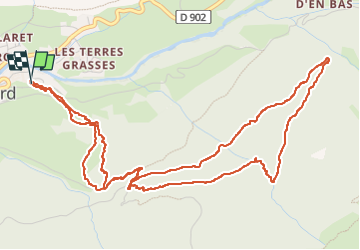

Length
7.5 km

Max alt
2011 m

Uphill gradient
510 m
Km-Effort
14.3 km

Min alt
1492 m

Downhill gradient
513 m
Boucle
Yes
Creation date :
2025-02-07 07:54:58.527
Updated on :
2025-02-07 11:51:37.069
2h29
Difficulty : Difficult

FREE GPS app for hiking
 SityTrail
IGN / Geographical institutes
SityTrail Plus
The world is yours!
About
Trail Snowshoes of 7.5 km to be discovered at Auvergne-Rhône-Alpes, Savoy, Val-Cenis. This trail is proposed by jeanmarcMasson.
Positioning
Country:
France
Region :
Auvergne-Rhône-Alpes
Department/Province :
Savoy
Municipality :
Val-Cenis
Location:
Lanslevillard
Start:(Dec)
Start:(UTM)
336654 ; 5017249 (32T) N.
Comments