


Autrens 4

tine60
User
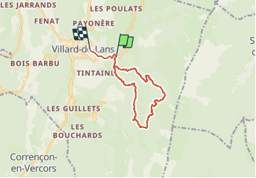

Length
11.9 km

Max alt
1500 m

Uphill gradient
461 m
Km-Effort
18.2 km

Min alt
1035 m

Downhill gradient
512 m
Boucle
No
Creation date :
2025-02-07 08:34:00.0
Updated on :
2025-02-07 14:26:13.746

FREE GPS app for hiking
 SityTrail
IGN / Geographical institutes
SityTrail Plus
The world is yours!
About
Trail of 11.9 km to be discovered at Auvergne-Rhône-Alpes, Isère, Villard-de-Lans. This trail is proposed by tine60.
Positioning
Country:
France
Region :
Auvergne-Rhône-Alpes
Department/Province :
Isère
Municipality :
Villard-de-Lans
Location:
Unknown
Start:(Dec)
Start:(UTM)
702094 ; 4993689 (31T) N.
Comments