


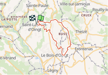
Saint Laurent, Bois Oingt Nizy, Moire, Oingt

adye
User


3h52
Difficulty : Difficult

FREE GPS app for hiking
 SityTrail
IGN / Geographical institutes
SityTrail Plus
The world is yours!
About
Trail Walking of 12.3 km to be discovered at Auvergne-Rhône-Alpes, Rhône, Val d'Oingt. This trail is proposed by adye.
Description
Départ de l'école de Saint-Laurent d'Oingt,
Direction Oingt en passant par Paradis,
Arrivée à Oingt, redescendre vers Bois Oingt en passant par les Verchères,
Bois Oingt : Les Carrières, l'Etang de Nizy
Direction Moire par le cimetière puis l'église
Retour vers Oingt
Positioning
Comments