


essai

fario
User
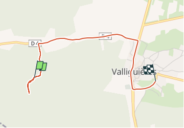

Length
3.5 km

Max alt
178 m

Uphill gradient
15 m
Km-Effort
3.8 km

Min alt
119 m

Downhill gradient
64 m
Boucle
No
Creation date :
2025-02-09 12:50:29.671
Updated on :
2025-02-09 13:17:07.63
26m
Difficulty : Easy

FREE GPS app for hiking
 SityTrail
IGN / Geographical institutes
SityTrail Plus
The world is yours!
About
Trail Walking of 3.5 km to be discovered at Occitania, Gard, Valliguières. This trail is proposed by fario.
Photos

Positioning
Country:
France
Region :
Occitania
Department/Province :
Gard
Municipality :
Valliguières
Location:
Unknown
Start:(Dec)
Start:(UTM)
625217 ; 4873723 (31T) N.
Comments