


chambolle

sturm
User
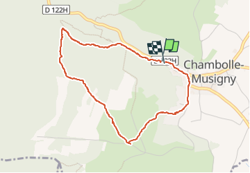

Length
4 km

Max alt
424 m

Uphill gradient
137 m
Km-Effort
5.8 km

Min alt
282 m

Downhill gradient
141 m
Boucle
Yes
Creation date :
2025-02-10 13:28:24.893
Updated on :
2025-02-10 14:50:52.834
1h21
Difficulty : Easy

FREE GPS app for hiking
 SityTrail
IGN / Geographical institutes
SityTrail Plus
The world is yours!
About
Trail Walking of 4 km to be discovered at Bourgogne-Franche-Comté, Côte-d'Or, Chambolle-Musigny. This trail is proposed by sturm.
Positioning
Country:
France
Region :
Bourgogne-Franche-Comté
Department/Province :
Côte-d'Or
Municipality :
Chambolle-Musigny
Location:
Unknown
Start:(Dec)
Start:(UTM)
647494 ; 5227811 (31T) N.
Comments