


bissy 12(02/25

pierrounet
User
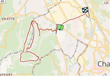

Length
11.2 km

Max alt
478 m

Uphill gradient
282 m
Km-Effort
15 km

Min alt
255 m

Downhill gradient
287 m
Boucle
No
Creation date :
2025-02-12 12:42:29.242
Updated on :
2025-02-12 15:42:45.939
2h59
Difficulty : Difficult

FREE GPS app for hiking
 SityTrail
IGN / Geographical institutes
SityTrail Plus
The world is yours!
About
Trail Walking of 11.2 km to be discovered at Auvergne-Rhône-Alpes, Savoy, Chambéry. This trail is proposed by pierrounet.
Positioning
Country:
France
Region :
Auvergne-Rhône-Alpes
Department/Province :
Savoy
Municipality :
Chambéry
Location:
Unknown
Start:(Dec)
Start:(UTM)
725283 ; 5051217 (31T) N.
Comments